Explore the LRT routes and bus interchanges on the Singapore MRT Map. The Singapore MRT 2024
map is entirely interactive. For more information, tap or hover over station names on the
map.
The Singapore Land Transport Authority’s (LTA) website hosts official maps in multiple languages, available for download as PDFs. You can check out the Metro Map DC, the Stockholm Metro Map in Sweden, or the world-famous London Underground tube map. The Singapore Land Transport Authority’s (LTA) website hosts official maps in multiple languages, available for download as PDFs. You can check out the Metro Map DC, the Stockholm Metro Map in Sweden, or the world-famous London Underground tube map.
Other Types of Transportation on the SMRT Map
All other transport alternatives displayed on the MRT map for public transportation and taxi services in Singapore
directions_bus Bus Services
The MRT trains provide convenient transportation to all regions of the island and encompass the majority of Singapore.
Changing from underground trains to green-coloured public buses at the interchange stations, which are indicated on the map by green bus markers, is a straightforward process if you require transportation to other, more specific locations.
tramCable Car
The 15-minute trip and breathtaking views of the Keppel Harbour region can be combined with the Singapore Cable Car, the ideal mode of transportation for tourists. is the perfect transportation method for tourists.
directions_boatFerries
You can change to the Ferries at the HarbourFront MRT station to travel by ocean routes.
The Harbourfront Center and the Singapore Cruise Centre are located here, and ferries depart from both of them to the numerous nearby islands as well as other nearby locations in Malaysia and Indonesia.
local_taxiTaxi Services
In Singapore, there are numerous taxi services to choose from. Use Grab, Southeast Asia’s equivalent of Uber. SMRT Taxi is another excellent local taxi choice for getting around quickly.
directions_subwaySentosa Express
Take the Sentosa Express monorail from the Singapore mainland to Sentosa island to reach Universal Studios Singapore and its stunning beaches.
For transportation on the island besides the monorail, there are the orange Sentosa buses and the Beach Shuttle. More details are available at: sentosa.com.sg
flightChangi Airport
The Changi Airport, is a destination in and of itself. If you are going or departing Singapore, you should plan to visit the magnificent gardens and other sights.
Mrt Map Singapore
Sights around Marina Bay
Easy access to Marina Bay and Singapore’s famous landmarks is provided by four of the six MRT lines. A few years from now, this area will also be traversed by the Thomson East Coast line.
See the amazing city sunsets and nighttime skyline by visiting the Marina Bay Sands’ sky bar and restaurant Ce La Vie, even if you are not staying there.
Marina Bay Sands is instantly connected to the Bayfront Station on the Circle Line and Downtown Line of Mass Rapid Transit rail system.
The best place to get a bird’s eye perspective of Singapore is from the enormous observation wheel by the river. The nearest MRT station is Promenade, which is reachable by the Downtown Line and the Circle Line.
There are other entertaining things at the place besides the observation wheel.
The Merlion
Just a short walk from the Raffles Place MRT station, the Merlion Park seashore in Fullerton boasts Singapore’s most iconic monument.
Remember also stopping by or booking a night at the famous Fullerton Hotel, a stunning 1928 neoclassical landmark near the Merlion.
Bayside Gardens
An incredible 250-acre nature park in the middle of the bay area with many gardens and the world-famous Supertree Grove Trees is an absolute must-see for any visitor to this extraordinary city-state.
Be sure to see the Flower Dome and Cloud Forest, two spacious conservatories.
Bay Area Theaters
Also known as Esplanade. “Step into our vibrant performing arts centre, where creativity knows no bounds. Immerse yourself in a world of artistic wonders that will inspire, enchant, and move you in ways you never thought possible.”
Your nearest MRT stations are Esplanade on the Circle Line and City Hall on the North-South or East-West lines.
River & Marina Bay
The blue dots on the MRT map that link to the blue Marina Bay circle represent the Singapore River.
The river is perfect for cruises to view landmarks and other sites. Or just travel to your destination in style by taking a leisurely river taxi and avoiding gridlock on the highways.
About Singapore’s MRT map
What led to the creation of Singapore’s Mass Rapid Transit (MRT) system, and what does it hold for the future? Now, let’s explore some fascinating information regarding the network as a whole and the SMRT map in particular.
The MRT’s inception dates back to the first part of the 1980s. On November 7, 1987, the first segment of the MRT, which was a portion of the red North-South line, started running. This leg covered a distance of six kilometres, or around 3.7 miles, and included five stations. Twenty more stations were built by the end of 1988, and the first plan was completed two years ahead of schedule on July 6, 1990, with the opening of the Boon Lay station on the East-West line.
East to west and north to south were the two main routes shown on Singapore’s first MRT map. Before the Woodlands Extension was started in 1996, there was another branch line that connected Jurong East and Choa Chu Kang. After that, it united with the North-South line.
The MRT system in Singapore is a remarkable achievement that has a long history and continues to alter the city’s transportation landscape. These facts provide an overview of the system.
Would you like to learn more about Singapore’s MRT system? We recommend seeing this insightful video. Watch this educational video on “The World’s Most Innovative Metro System” on YouTube, produced by the RMTransit channel. It’s an excellent approach to discovering more about this state-of-the-art transportation system.
Two public transit operators share the MRT system in Singapore. SBS Transit (SBS) and SMRT Corporation Ltd. (SMRT). During the same operational hours, the system is always in operation, including on weekends, from 5:30 am to midnight.
During peak hours, trains depart every two to three minutes, while during off-peak hours, they depart every five to seven minutes.
Train service between Woodlands North and South on the Thomson-East Coast Line will terminate early every day, Monday through Sunday, at 9:00 pm. During the weekends (Saturday and Sunday), the services will start one hour later at 6.30 am.
Singapore MRT Lines
Six lines and more than 120 stations make up the lines, which have a combined length of more than 200 kilometres (124 miles). By 2040, it is anticipated that The MRT lines will have doubled in length, reaching a total of close to 400 kilometres (about 250 miles). The present six lines will be increased, and three more new lines will be constructed, to achieve this.
Singapore’s MRT is the most costly, congested, well-established, and longest-running MRT system in Southeast Asia when all of its lines are combined. In addition, it is well known for having the longest stretch of fully automated railway lines with driverless trains in the entire globe.
Travellers can find it easier to navigate Singapore’s MRT stations by using codes in addition to names, which are based on the names of the lines and the stations’ locations on a map for that specific line and itinerary. Finding stations where you can change trains and move to another MRT or LRT line is also made easier by the interchange codes. (The codes are explained on this page higher on.)
The bulk of visitors and Singaporeans usually know the name of the station they need to visit. They may not know, though, that a few of the station names have interesting histories and beginnings that explain how they got to be called what they are now. For example, the Dakota Station on the Circle Line was named after the many commercial Dakota DC-3 aircraft operating in the Dakota region. If you’re interested, locomole.com has an article about these stations.
The fact that most of the underground stations are strong, sufficiently deep to serve as bomb shelters, and built to withstand aerial bombing strikes is another amazing feature of the stations.
Tickets, fares and services
Tickets for MRT fares can be purchased using a few different methods. Tickets are easily obtained at all stations via the General Ticketing Machines (GTM) with a Visa or MasterCard.
Another option for tourists is the Singapore Tourist Pass, a special EZ-Link stored value card. You can purchase the card for one, two, or three days, and during those days, you can use the MRT and other public transit as often as you’d like. There is also the equivalent NETS FlashPay card, which may be used for both travel and shopping.
There are additional smartphone app service options available for your Android and iPhone devices. One option is SimplyGo. In addition, transit information is available through the SMRTConnect app for both Android and iPhone.
See the Singapore Tourism Board’s homepage for information on transportation in Singapore. You may find helpful step-by-step instructions on YouTube for purchasing MRT tickets, as well as advice on navigating the system.
When exploring the vibrant city of Singapore, navigating its efficient and extensive transportation network is a breeze with the Singapore MRT map. The Singapore Mass Rapid Transit (MRT) system is renowned for its punctuality and accessibility, making it the preferred choice for both locals and tourists. The MRT Map Singapore showcases an intricate web of train lines that connect key destinations, ensuring that you can effortlessly reach popular attractions, business districts, shopping centers, and more. With its user-friendly layout and clear color-coded lines, the MRT map simplifies your travel experience, allowing you to plan your routes with ease. Whether you’re looking to savor the cultural delights of Chinatown, indulge in shopping sprees on Orchard Road, or immerse yourself in the lush greenery of the Singapore Botanic Gardens, the MRT map serves as your trusty guide. Beyond its practicality, the MRT system also offers a glimpse into the city’s commitment to cutting-edge urban development. So, hop aboard the Singapore MRT, and let the well-designed MRT map be your ticket to discovering the captivating wonders of this cosmopolitan metropolis. Experience the convenience, efficiency, and connectivity that the Singapore MRT map brings, ensuring a seamless journey as you uncover the treasures of this remarkable city. For sharing info check out our Privacy Policy
Benefits Of The Singapore Mrt Map 2024
People connected with the MRT system in Singapore identify with this level of public transit efficiency and comfort. Having one of the most sophisticated and linked metro networks in the globe has drastically transformed Singaporeans’ way of mobility.
Source Wikipedia
I. Evolution of MRT MAP
Singapore MRT Map 2024 has an interesting history of how it came to be. The brainchild of Singapore’s urban influx from humble origins to the wide-ranging network hoarded by it today is the SG Mrt Map 2024.
II. Advantages of SMRT MAP
A few significant benefits that have contributed to its wide popularity include the following:
MRT Accessibility: MRT is a lot more accessible to residents than it is to tourists.
Less Traffic Jams: The MRT Map Singapore 2024 has also been of great benefit to the country by reducing the traffic congestion on its roads.
Environmental Impact: As a green mode of transport, the MRT is also in line with Singapore’s effort towards sustainability.
Transit is a cost-effective way for daily travel: When it comes to the economic advantages of using MRT as an affordable mode of going back to work day in and out,
III. SG MRT Map 2024 Design
This easy-to-understand layout of the MRT map 2024 improves navigation and makes commuting with Metro Rail Transit even easier.
Seamless Integration with Buses & Other Transport Modes: The SG MRT map 2024 is integrated into buses and other transport forms, giving commuters a complete travel solution.
IV. Technological Advancements
MRT experience has been further enhanced by including the latest technologies.
Smart Ticketing Systems: Automated ticketing systems have made the entire process more efficient for daily commuters.
Live Alerts: Passengers receive instant alerts to know what’s happening with delays and downtime.
V. Future Developments
Moving forward, the MRT system in Singapore has exciting prospects.
Further Growth: The company has ongoing and planned expansions, which will improve cold water resilience while also providing greater connectivity to various parts of the growing population and urban developments Seamless Technology Integration in the Era of Smart Cities: The MRT will play a significant role in connecting Singapore’s future smart city projects.
VI. User Experience
Given how it caters to a wide range of demographics and ranks users’ comfort, the MRT has taken up some pieces of legacy transit operations.
Accessibility for Differently-Abled: We aim to improve the accessibility of the Singapore Metro Map so that persons with physical disabilities can easily use it.
VII. Economic Impact
It is not just the commuters who have gained from MRT systems; its economic benefits can also extend far.
Proximity to SG MRT stations will also benefit local businesses in the area by increasing exposure and ease of access, thus contributing positively to the economy.
Creation of Jobs: As the construction, regular maintenance and operation of the SG MRT system require many individuals, there is a boost in job opportunities, which results in increased employment growth.
VIII. Challenges and Solutions
The MRT is indeed a success story and likewise brings with it its own set of challenges that could be overcome using new approaches.
Overcrowding Problems: The management of overcrowding is important if you want to maintain the efficiency and attractiveness of MRT Map Singapore.
Maintenance Hurdles: Preventive maintenance approaches are necessary to avoid downtimes and guarantee seamless computing operations.
Technology Improvements: Technological improvements need to be continuous so that the system always has the best efficiency and safety.
IX. Community Engagement
The role of the community in planning and decision-making is important to ensure that the SG MRT system serves public needs.
Public feedback mechanisms: There is no better barometer to gauge public opinion, and this will keep changing in a dynamic environment.
Participatory planning: Engaging the community at any point in time while it is planned will make sure that the needs to cover certain places are well addressed by the MRT system.
X. International Recognition
Based on maps of Singapore, this has earned worldwide respect and established a benchmark for Metro Systems all around.
International Benchmark: most cities across the globe base their metro system building and expansion on Singapore.
XI. Sustainability Efforts
Sustainability Initiatives Sustainability is central to the operations of the Singapore Metro Map MRT system.
Eco awareness: The MRT system does participate in Singapore’s environmental goals, from low-energy operations to waste generation.
XII. Lessons for Other Cities
Understood differently, the performance of this MRT system has practical applications for other cities looking to build or improve public transportation options.
Replicable success: From his analysis of factors contributing to Singapore’s triumph, other cities can adopt strategies that suit their contexts
Lessons from Singapore, without Lessons in Cultural Adaptation: Cities can learn a lot from Singapore’s model, but due to the different cultural, geographical, and demographic issues, cities will drive their adaptation.
XIII. Government Initiatives
In this manner, the MRT is a system that cannot escape from being supported by government policies.
For Peace Hwang Architects, the central issue was MRT integrity: “Public transport is fundamental in Singapore – it keeps our economy humming by ensuring business continuity,” she says. The familiarity and comfort of train travel have reassured many about returning to public life while remembering close encounters could be a trigger for anxiety once we attempt to return to civilian things.
Source Wikipedia
XIV. Conclusion
As a result, this is the Singapore 2024 MRT system we will see built as evidence that good urban planning and innovation come from every class citizen. With its countless advantages and continued enhancements, HS2 is becoming a world leader in environmentally sound public transportation. The same map is also present in the Singapore MRT Map 2024 pdf.
What is the Smrt network map?
All the fumblings about a city charged with electricity and depictions of buildings can confuse even seasoned soothsayers. But despair not, for amidst the oh-so-postmodern chaos of our metropolis, there is a unifying element; an essential point of reference – as any poor Kurt-less Slaughterhouse 5 can tell you with his tragic so-it-goes: The SMRT network map. Embark on your journey into the colourful patchwork of nodes that compose Singapore’s transportation network, and you will find yourself at home with the SMRT map as it leads handsomely decked in its purposeful lines and lively hues.
The initial thing that grabs your attention is the artfulness of the map. It is not just a handy map of paths but also an unfolding narrative about the movement within a city. These lines are bold, slithering through the heart of the urban landscape to tell a story of connectivity. The colours are not merely bizarre shades to my eyes. Each colour represents a feeling, andall of them are feelings I belong to and am familiar with as well. It is a harmonious map that creates the perfect harmony for people to follow and move.
As your finger follows the winding routes, you feel a sense of reverence and amazement. The SMRT network map – your guide to man-made progress. The vast infrastructure that now exists atop what was before simple transportation is a direct result of the ongoing work of planners and engineers. As long as trains are plunging through its veins, the map will continue to reflect people’s dreams and propel all citizens ahead.
However, it is more than just the lines and colours; every station bears an embedded story. Every dot on the map is a portal to something new and an embodiment of what this city does best – its myriad diversities. The SMRT network map has a myriad of potentialities, from the hustle and bustle of the streets of Orchard to the vast landscapes of Jurong. A show of good faith, reminding you that wherever you stand, there is always a road leading to the next path or discovery.
In a world of chaos and uncertainty, the SMRT network map represents reliability. It serves as a guiding light in an otherwise treacherously stormy sea of relentless uncertainty. Seemingly inactive while the commotion of people unfolds around you: connectivity and convenience in map form. Download MRT map 2024 in pdf for Safari offline visiting guides.
SMRT Network Map Conclusion
In other words, it is way more than just a map – an answer to the soul of a city. Visually enticing, a sensual journey that calls to the soul. Therefore, the next time you negotiate your way around easily through the urban maze in Singapore, let it be led by this SMRT network map, which is a light of hope and a cooking pot for endless opportunities.
What is the longest MRT line in Singapore?
That is the MRT line which we will focus on today – The East-West Line. Its route spans 57km, linking Pasir Ris in the east with Tuas Link at the western end. With its long route, this MRT line offers commuters quick access to different parts of the town, which makes it one of the city-state’s longest MRT lines.
Is MRT 24 hours in Singapore?
The short answer is yes: MRT runs 24 hours in Singapore. This 24/7 service provides commuters with all-day access to vehicles. It fits into all schedules, making it convenient and increasing the perception that public transport can be a dependable option at any time of day.
FAQs
Is the MRT map easy to understand for tourists?
The color-coded lines and symbols make it tourist-friendly.
How do I know which ticket to buy?
You can consult the fare matrix at each station or use the MRT app.
Are there any discounts for using an EZ-Link card?
Yes, frequent travellers enjoy fare discounts with the card.
What time does the MRT system operate?
Most lines start around 5:30 AM and run until midnight.
Is it wheelchair accessible?
Yes, most stations have facilities to accommodate passengers with disabilities.


 zoom_in
 zoom_in
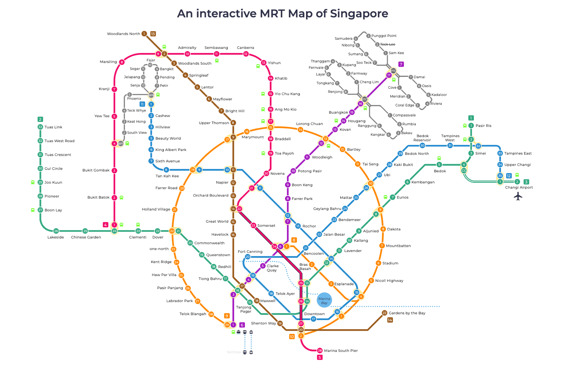 zoom_in
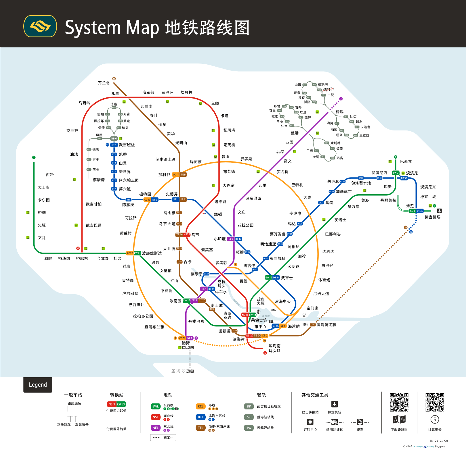 zoom_in
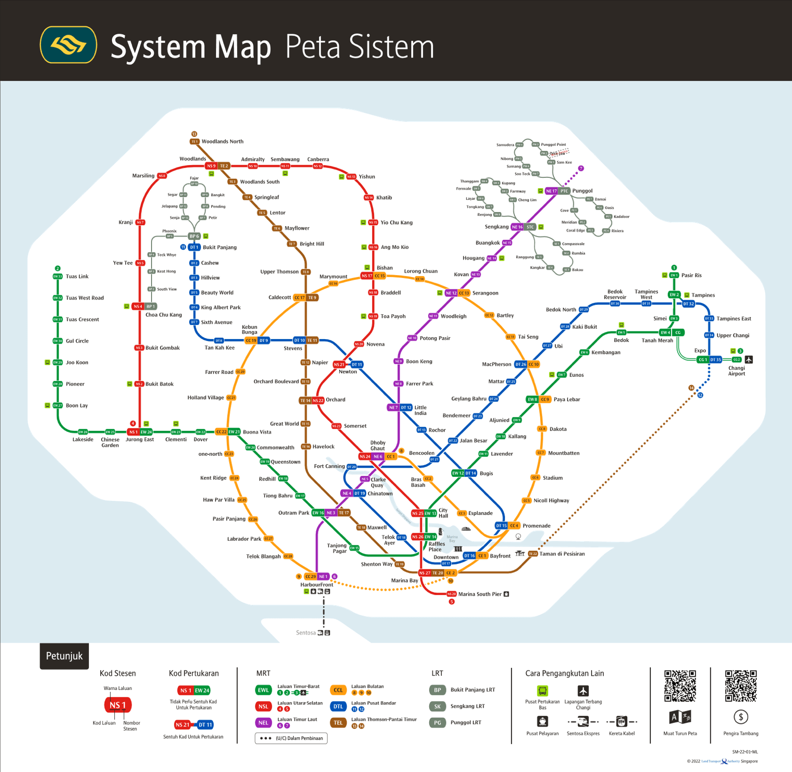 zoom_in
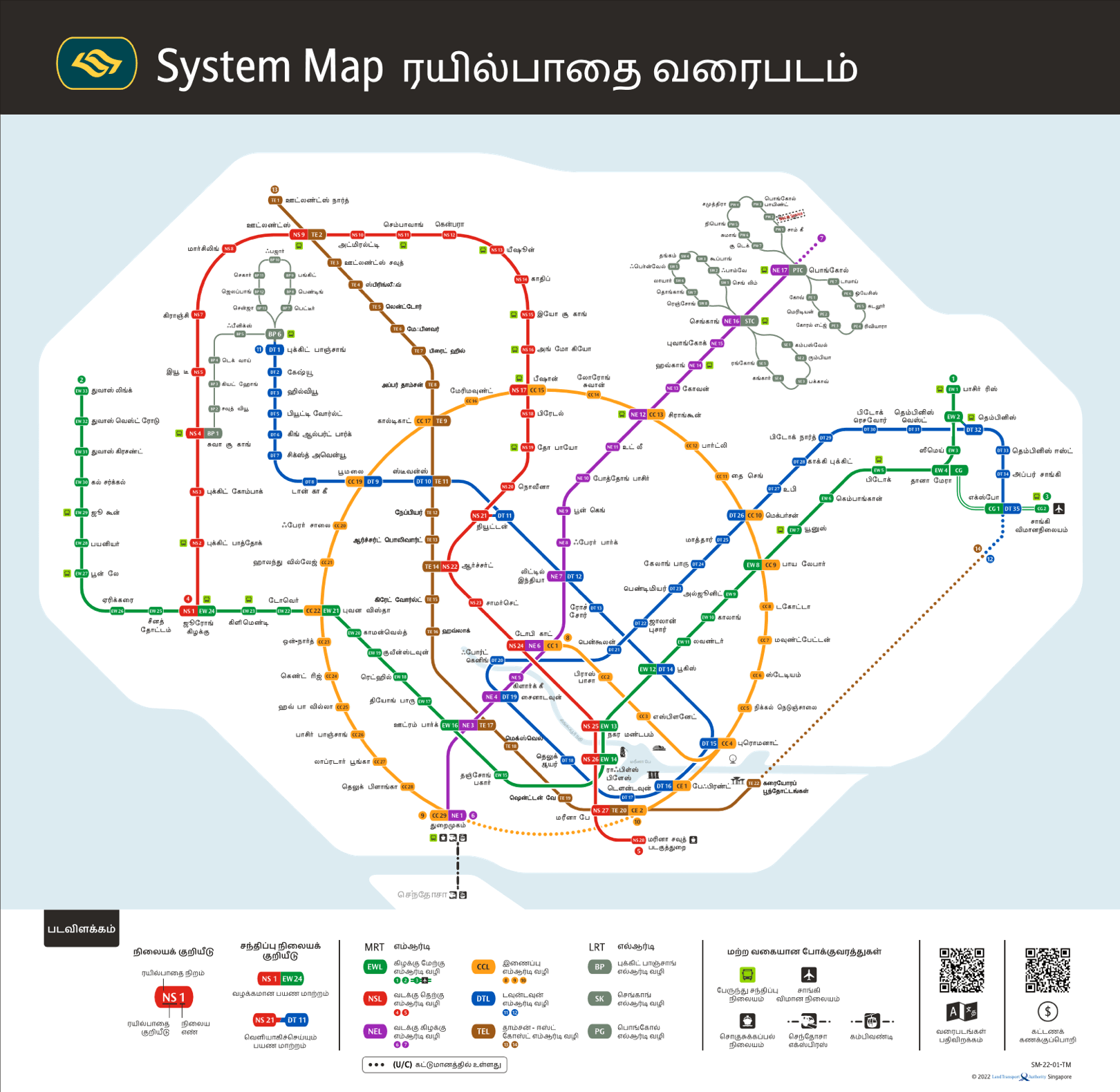 zoom_in
 zoom_in
 zoom_in
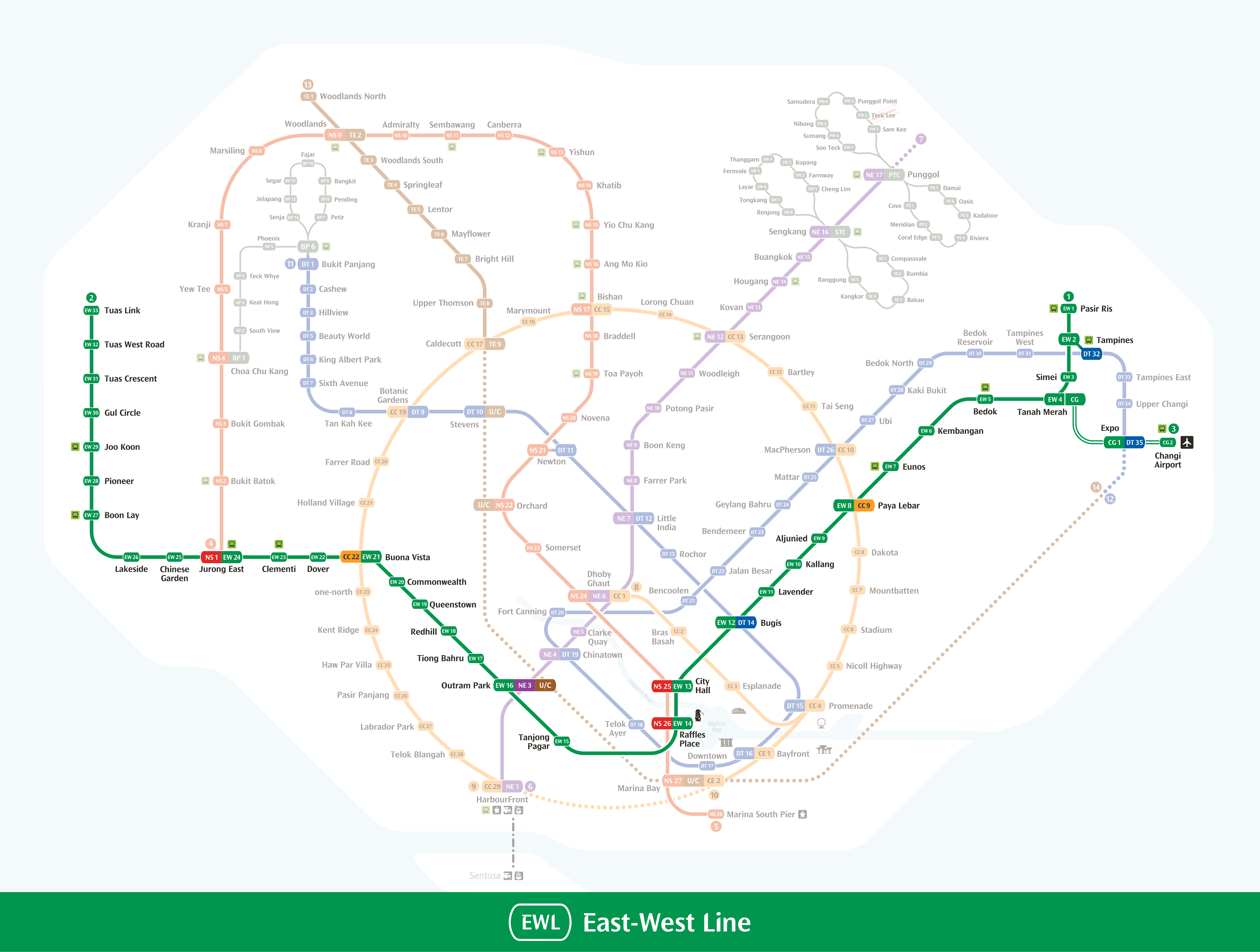 zoom_in
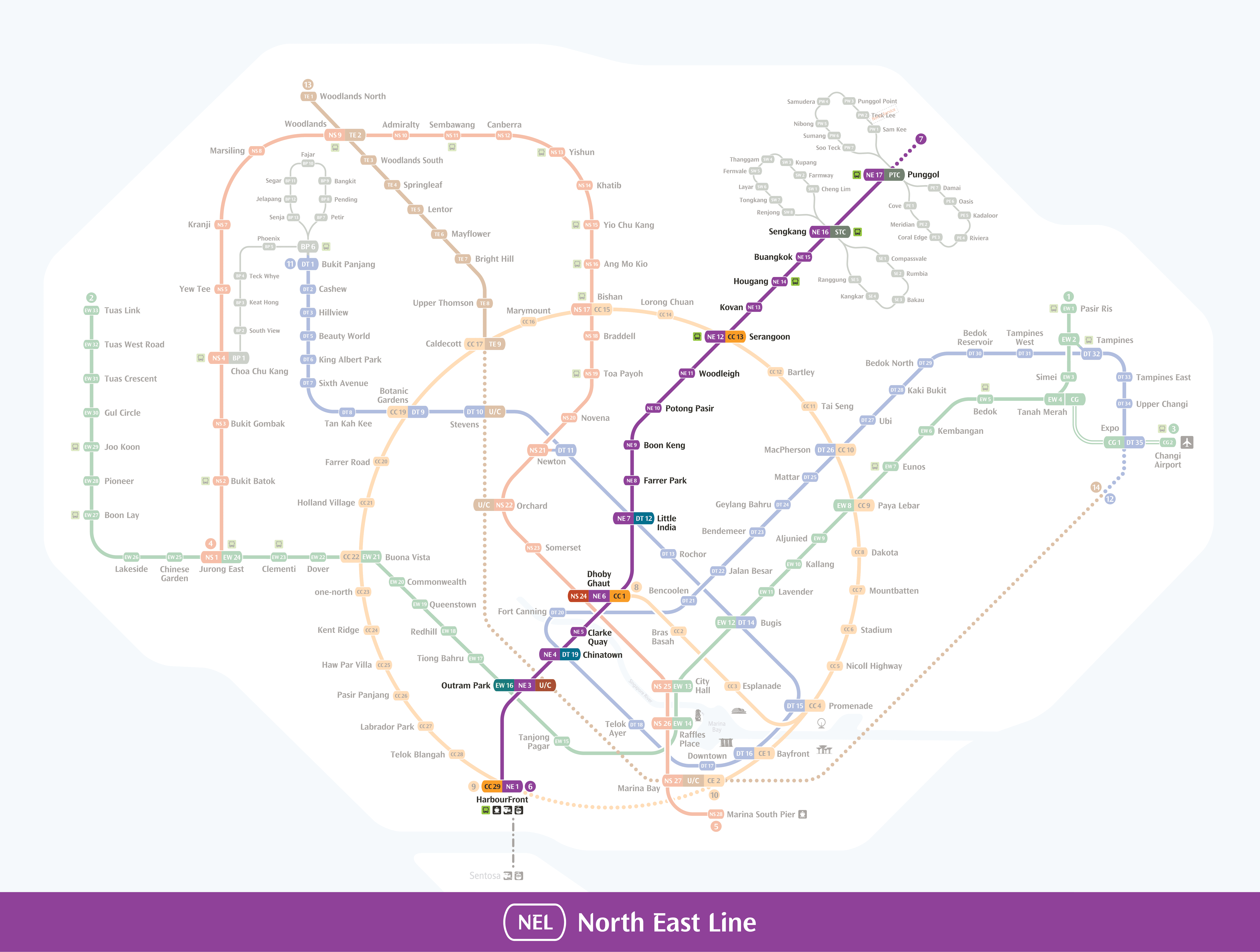 zoom_in
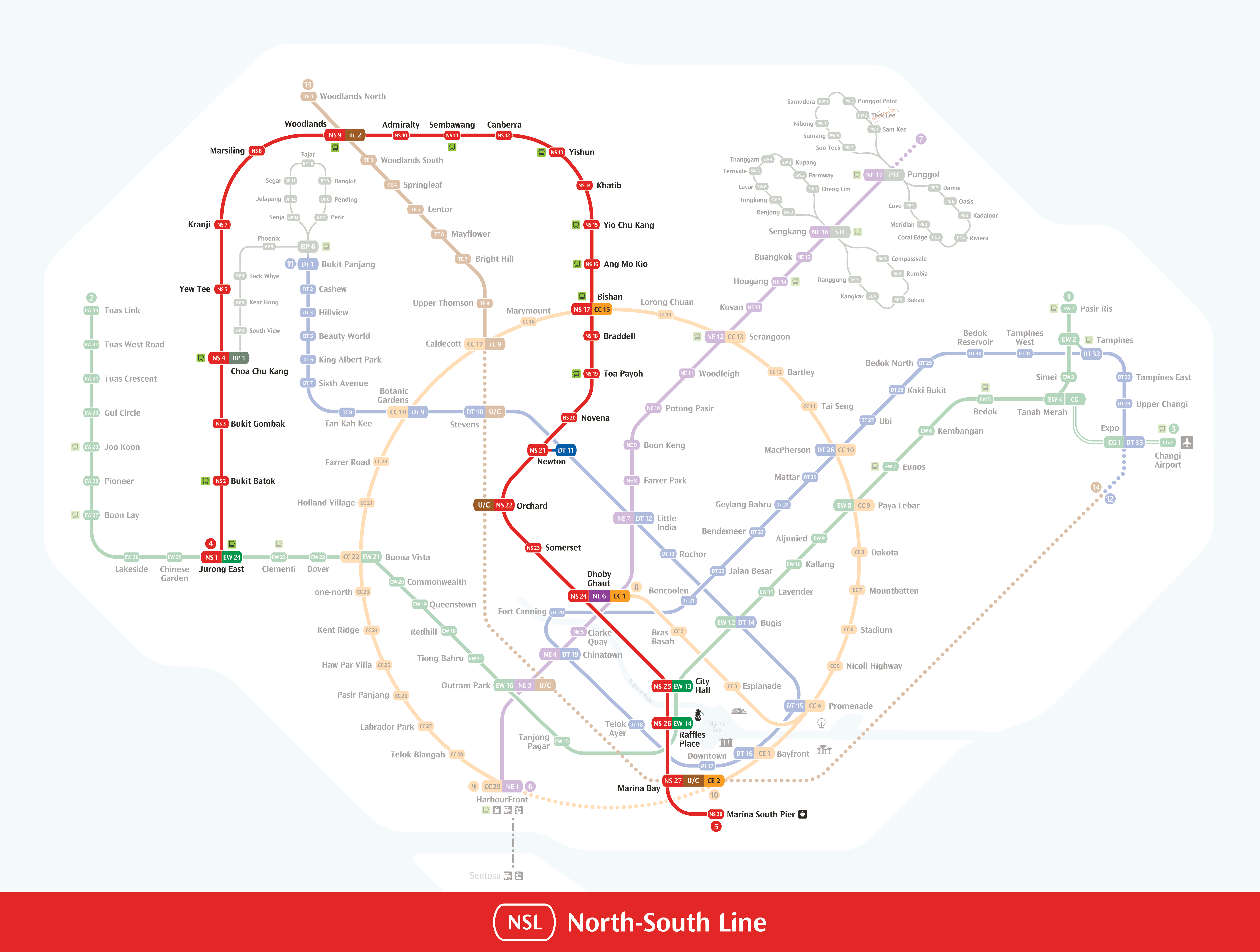 zoom_in
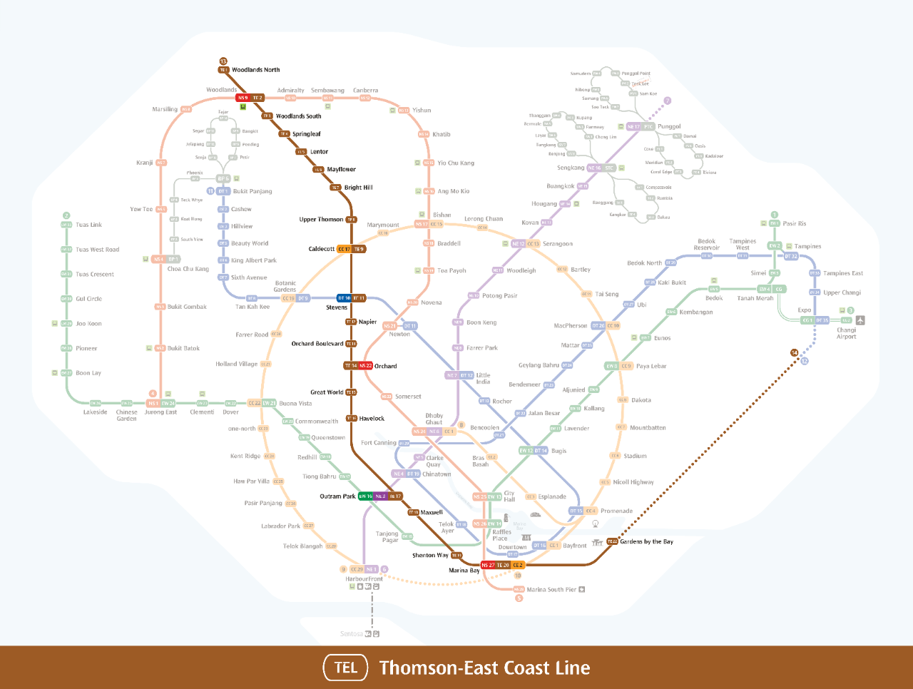 zoom_in
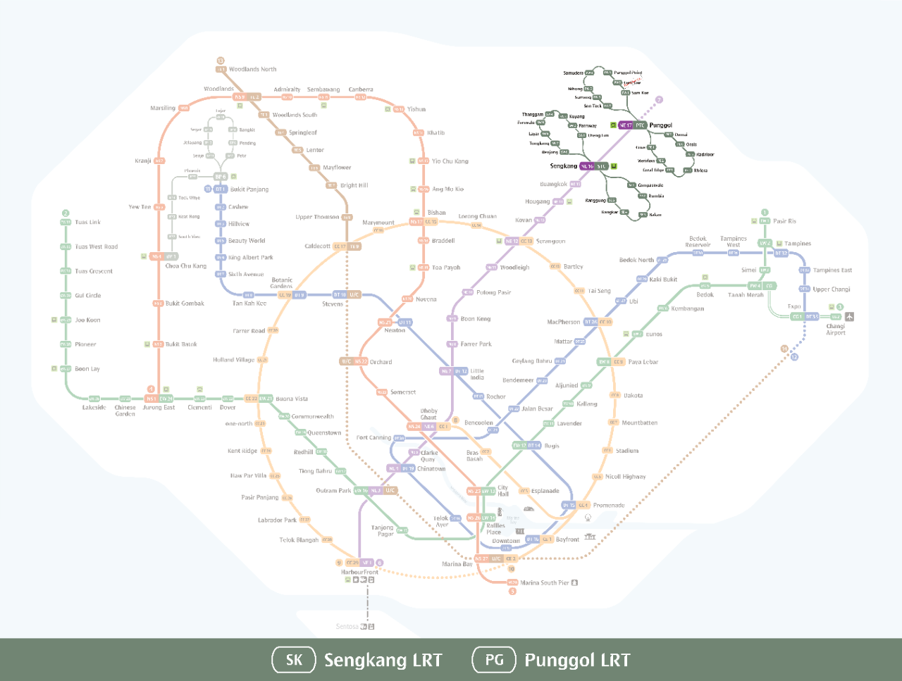 zoom_in
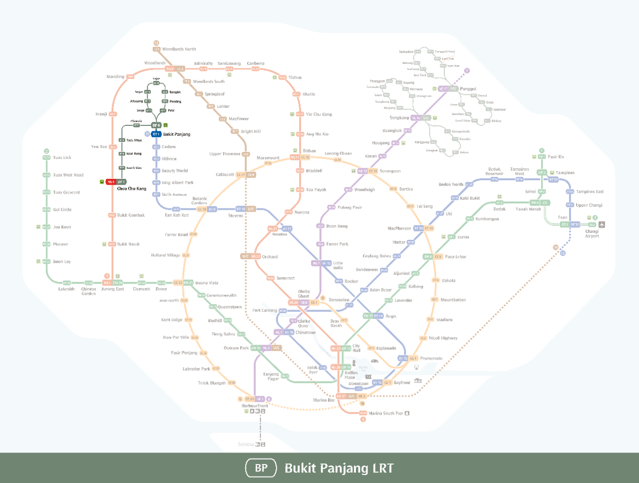 zoom_in
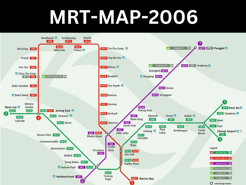 zoom_in
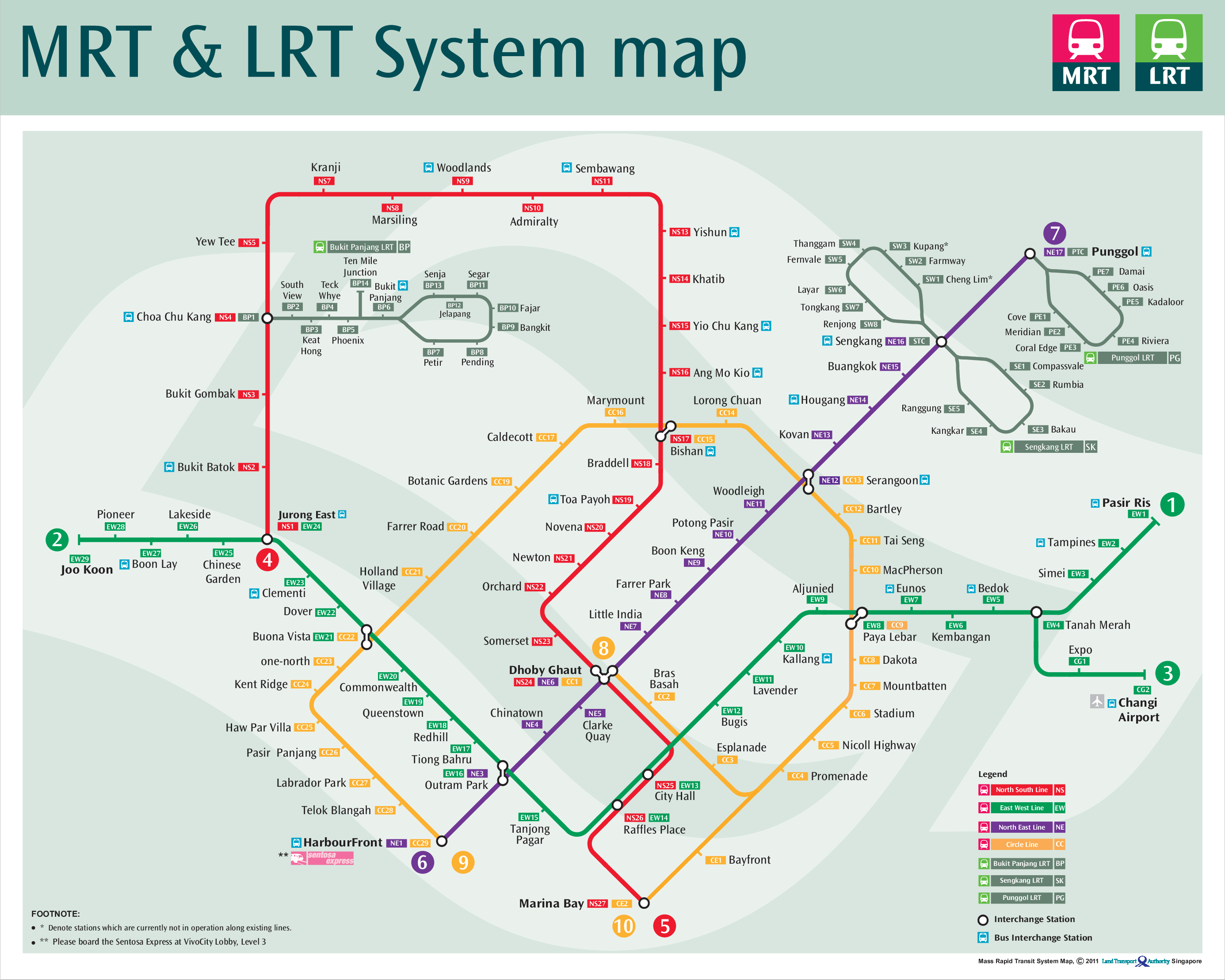 zoom_in
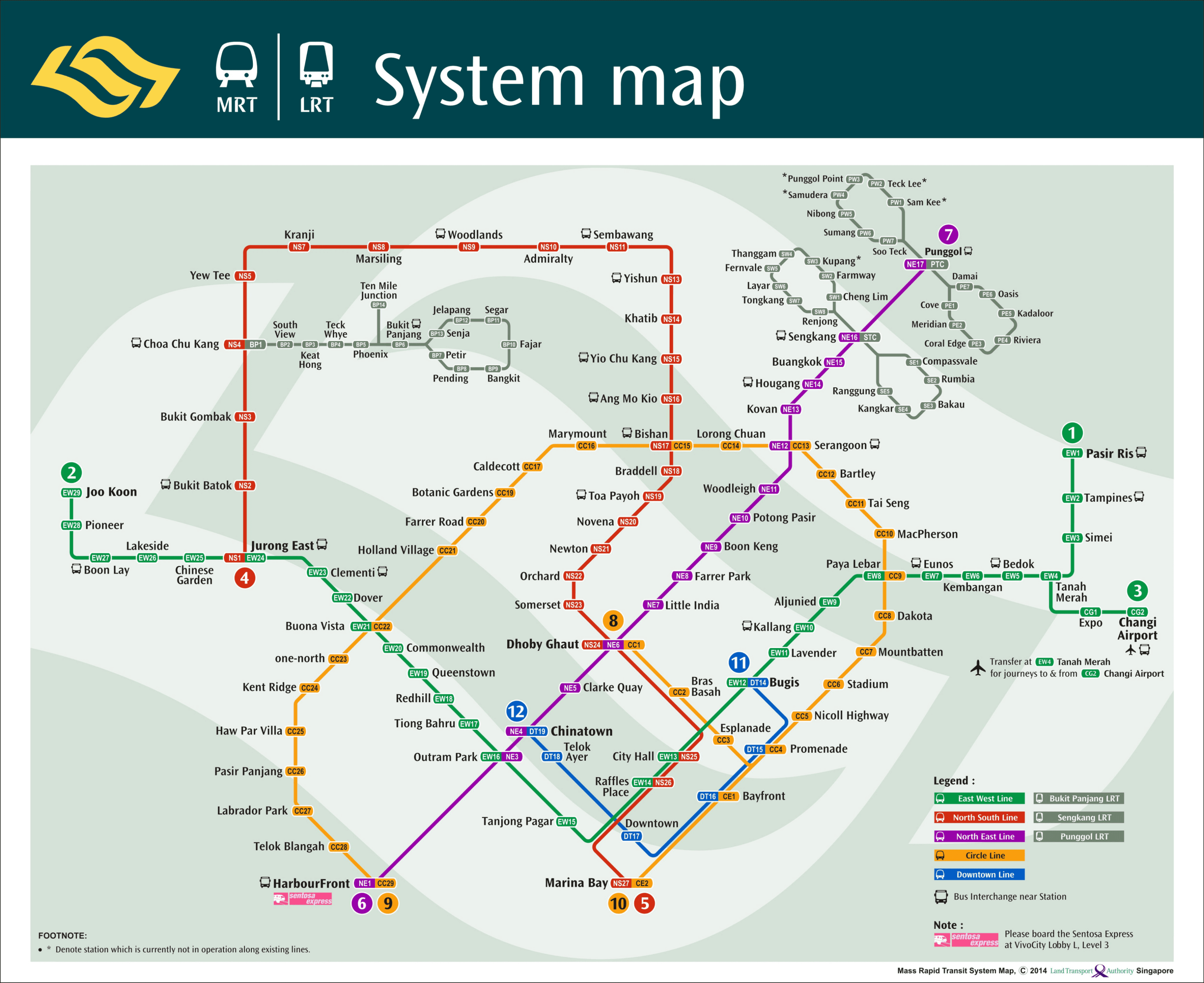 zoom_in
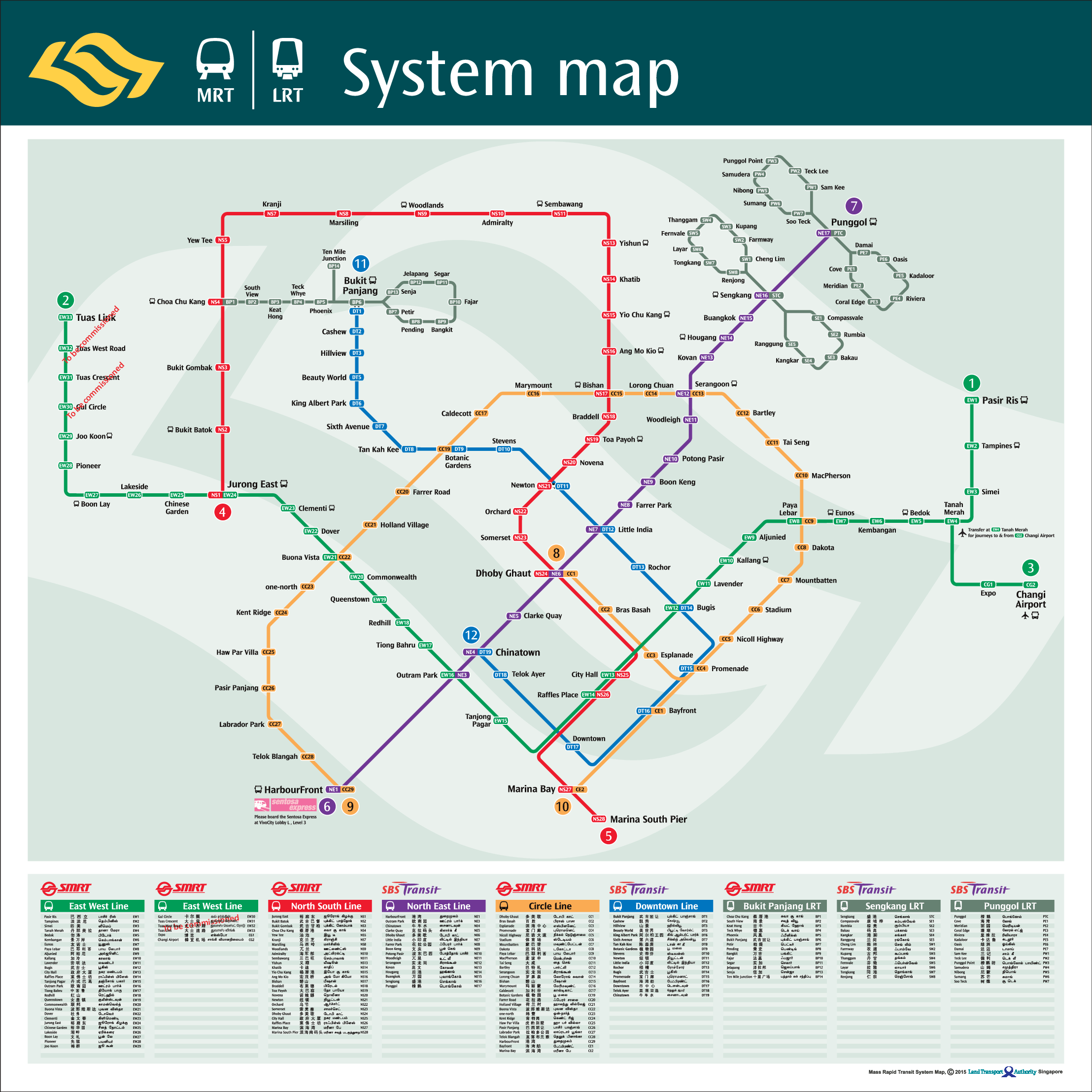 zoom_in
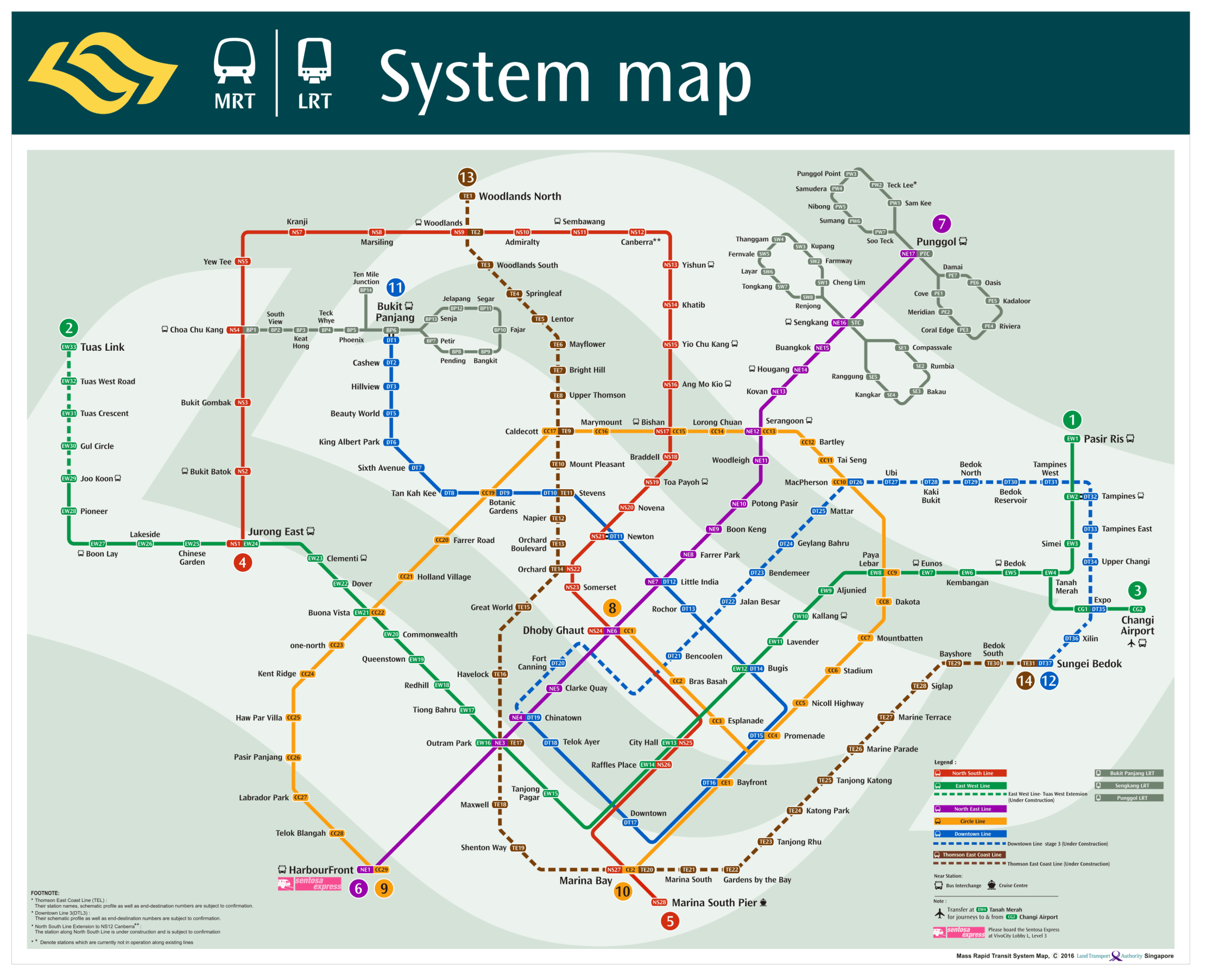 zoom_in
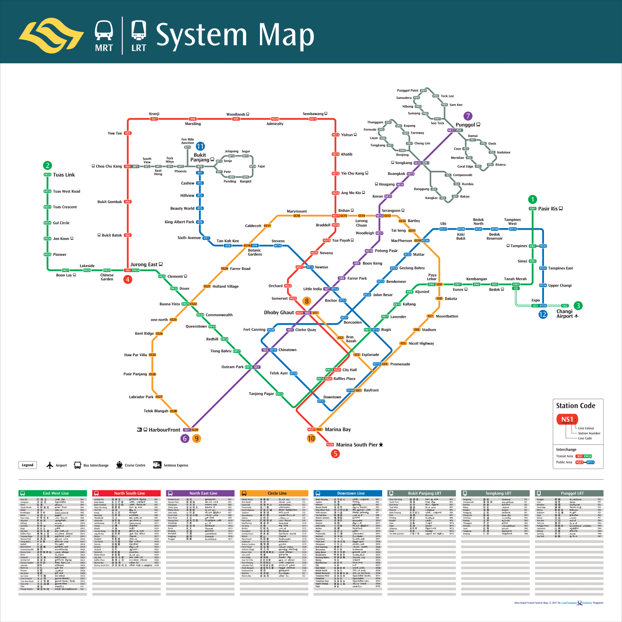 zoom_in
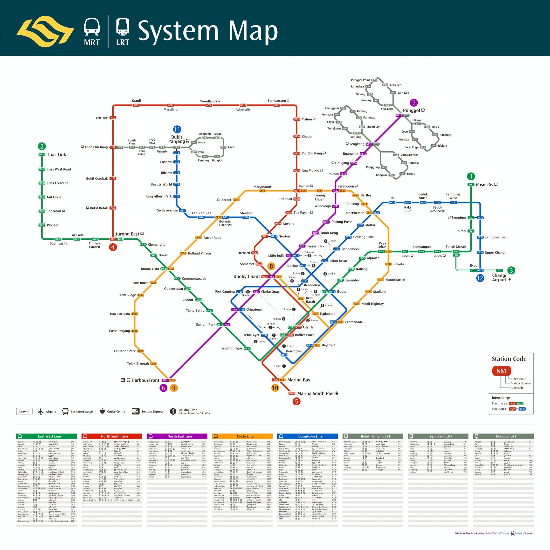 zoom_in
